Since earliest times, maps have been a source of interest, not to say fascination. With the oldest one presumably dated 6000 BC until modern cartography, maps developed into a unique representation combining art, geography, and military power (1). But what is the true meaning of a map in a post-colonialist society imposing norms and habits which can be very far from the representation to which the author aspired? In his publication (2), H. Mazurek invites us to compare the points of view of the geographer as opposed to the cartograph. The author argues that the first one should overcome a cartesian vision and engage in the construction of spaces where territoriality and human behavior are intrinsically linked. Through a critical approach of how maps should represent the true meaning of places and their historical scope, this publication reminds us that spaces are social constructions and indirectly questions the significance of humanitarian mapping. Likewise, Kitchin and Dodge (3) explain why maps are ephemeral being context dependent. The authors develop here an unfolding approach of cartography questioning the real meaning of lines’ arrangement, inviting us to join a philosophical shift from “how things are” to “how things develop”.
There is no doubt that open geographic database combined with community initiatives may contribute to SDG’s achievement (4). In their publication on the evolution of humanitarian mapping, Herfort & Al (5), recall the amazing development of OpenStreetMap and how the OSM community improved the footprint knowledge of places that were poorly “documented”. But at the same time, the authors draw our attention to the bias generated by an overrepresentation of places featuring a high human development index with sophisticated data at the expense of low-income and often vulnerable communities. By doing so, the authors underline one the most challenging issues of mapping: using technology to improve resilience and putting innovation at the core of human well-being.
No one can criticize mappers engaged in disaster mapping, wherever they are, but local resilience can hardly be achieved without a local commitment of those who are directly impacted. In a remarkable book (6) showing how participatory mapping could be implemented in Maputo, Mozambique, one of the poorest areas in the world, V.C. Broto & Al. review all the issues generated by a “participatory action plan” engaging citizens through the co-production of climate change knowledge. Understanding local needs will facilitate the planning process and there is a democratic imperative to include all urban citizens in devising their own future. But how can residents engage with complex climate change information? Will conditions that led to the creation of urban injustices be overcome? Engaging in a process of co-learning production confronts inevitably with a difficult challenge: framing issues shaping the inhabitant’s daily life within the ambiguities of modelling climate change and complex concepts such as risks and uncertainty.
More than ever, the increasing complexity of socio-ecological urban systems requires a thoughtful exercise including mapping and pedagogical tools. Convincing citizens of the challenges they face and engaging them in a risk- management approach as full stakeholders is one thing. Explaining them the nature of systemic socio-ecological vulnerabilities is another. To this extent, the role of humanitarian mapping goes far beyond the simple fact of editing a map and questions the way citizens can be appropriately empowered. JP de Albuquerque and AA de Almeida address this issue brilliantly (7), showing the ambivalence, not to say the contradiction, between enabling citizens to produce themselves data, and at the same time, generating consciously or unconsciously bias due to their role of “data providers” sending signals used in ways that are frequently opaque and outside their control and accountability. Building on the groundwork of educator and sociologist Paulo Freire (8), the authors invite us to learn the way knowledge should be transferred from expert to non-expert citizens. Forty years after the Pedagogy of the Oppressed, (9) Freire teaching happens to be of an amazing actuality, translated into the Waterproofing data project (10)(11). This mapping initiative, supervised by JP de Albuquerque, addressing flooding governance issues in flood-prone marginalized urban neighborhoods of São Paulo and Rio Branco, brought together researchers, institutions, and citizens of three different countries from 2018 to 2021. The dialogical approach inherited from Freire legacy was undoubtedly the requirement to be fulfilled to improve urban resilience. It recalls all scientists that empathy towards vulnerable communities is not enough. Pedagogy is crucial; it cannot be decreed; it needs to be learned.
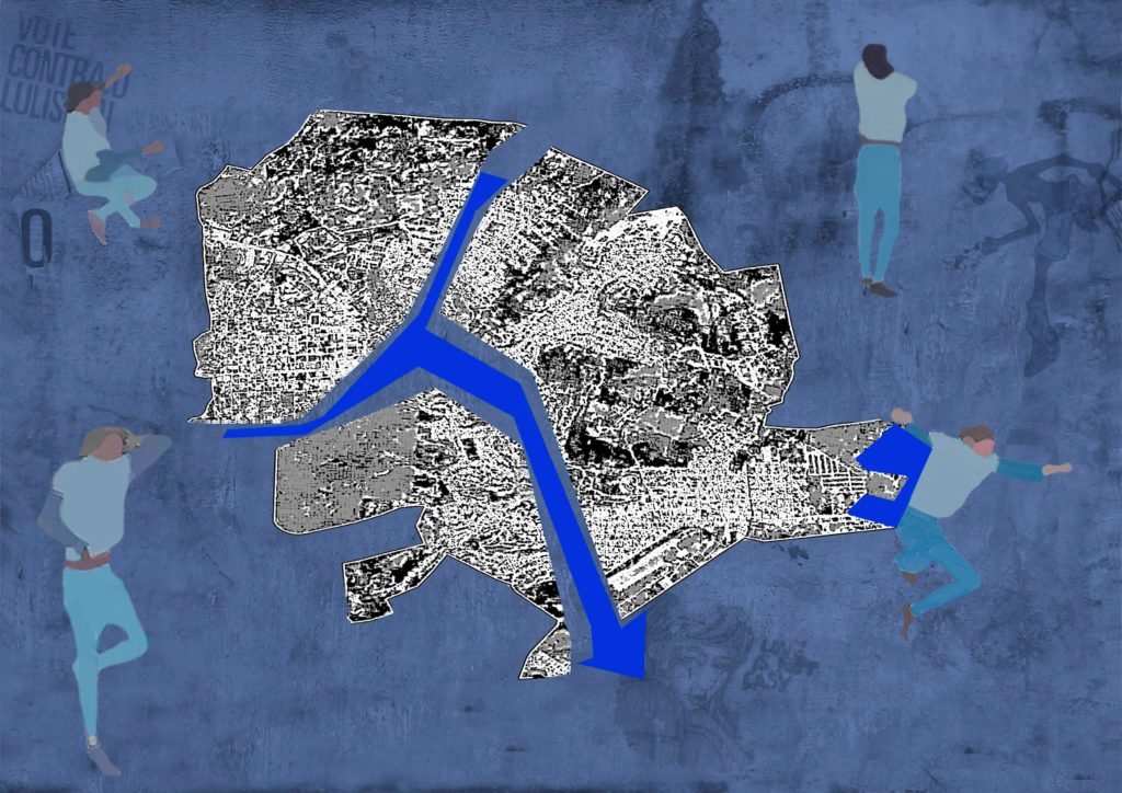
The below “virtual” collage is inspired by PCdO Campos & I Paz study (12) on the mapping of Itaperuna, Rio de Janeiro, BR. In January 2020, the worst floods registered since 1932 impacted dramatically this urban area. The map itself shows the flood occurrence of the Muriae river during the event. The study used highly skilled techniques based on fractal analysis investigating the (lack of) drainage performance and its impact on flooding cartography usage. Confronting the absolute objectivity of sophisticated measurements to the inherent subjectivity of human behavior translates here into a deconstruction-reconstruction process of the mapping. Itaperuna looks fragmented in three parts, but together with the river and its redesigned flooding, they constitute an indissociable whole and an integral part of the social space. All around, silhouettes are talking, lying down, dancing or listening on a background of graffiti, a way to recall the challenge of pedagogy when teaching to non-expert citizens the meaning of urban resilience.
(1) https://www.gislounge.com/mapping-through-the-ages/
(2) https://doi.org/10.3917/lig.774.0109
(3) https://www.researchgate.net/publication/237713740_Rethinking_Maps
(4) https://youtu.be/0XTBYMfZyrM
(5) https://www.nature.com/articles/s41598-021-82404-z
(6) https://www.uclpress.co.uk/products/83516
(7) https://doi.org/10.7765/9781526137005.00028
(8) https://www.freire.org/paulo-freire/itemlist/category/110-paulo-freire
(9) https://envs.ucsc.edu/internships/internship-readings/freire-pedagogy-of-the-oppressed.pdf
(11) https://www.researchgate.net/publication/346550606_Risk_and_Resilience_Management_in_Co-production
Pingback: Itaperuna – Resi-city